
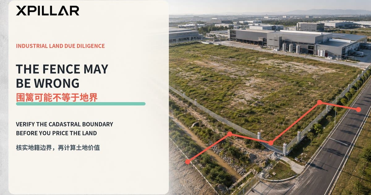
Is the Fence on the Legal Boundary? 11 Checks Before Buying Industrial Land in Malaysia
围篱是否位于法定地界?购买马来西亚工业土地前的11项边界检查
Answer first/ 先说结论
Do not assume that the fence, drain, gate, road, satellite outline or marketing KML marks the legal boundary of Malaysian industrial land. Before buying, leasing or developing a factory or industrial site, align five things: the registered title and lot, JUPEM cadastral information, an on-site survey by an appropriately licensed land surveyor, the physical occupation of the land, and the legal rights supporting access and utilities.
不要因为现场有围篱、排水沟、大门、道路、卫星图边线或业主提供的KML,就认定它们代表马来西亚工业土地的法定边界。购买、租赁或开发厂房及工业地之前,应把五项资料对齐:注册地契与地段、JUPEM地籍资料、合资格注册土地测量师的现场测量、土地当前实际占用情况,以及支持出入口和公用设施的合法权利。
If these layers do not match, the buyer may receive less usable land than expected, inherit an encroachment, lose a working access route, discover that part of a building sits outside the lot, or face rectification and approval costs after completion.
如果这些资料不一致,买方可能实际取得的可用土地少于预期,也可能承接越界建筑、失去原本使用的通道、发现厂房部分建在地段以外,或在成交后才承担纠正和重新审批成本。
JUPEM explains that its cadastral functions include land-title surveys, quality control of licensed land-surveyor work, preparation of Certified Plans and maintenance of the National Digital Cadastral Survey Database. A JUPEM Certified Plan (Pelan Akui or PA) shows information such as the lot number, area, boundary lines, bearings, distances and corner coordinates. That is materially different from relying on a fence or an online map.
JUPEM说明,其地籍职能包括土地权属测量、监督注册土地测量师的工作质量、编制认证图(Pelan Akui),以及维护国家数码地籍测量数据库。Pelan Akui会显示地段编号、面积、边界线、方位、距离及角点坐标等资料。这与只看围篱或网络地图有本质区别。
Practical rule: Use online maps to locate the property. Use cadastral records and a licensed boundary survey to verify what is legally inside it.
实务原则: 网络地图用于寻找位置;地籍资料和注册边界测量才用于核实法律上属于该地段的范围。
Why boundary risk matters in industrial property
为什么工业地产的边界风险特别重要
Boundary discrepancies are particularly costly for industrial sites because operations depend on every metre of usable space.
工业物业每一米可用空间都可能影响运营,因此边界偏差的成本通常较高。
A small overlap can affect/ 一个不大的重叠范围,就可能影响:
- a guardhouse or security gate;
保安亭或大门;
- 40-foot container turning and queuing space;
40尺货柜车转弯和排队空间;
- a loading canopy or dock;
装卸雨棚或月台;
- fire-appliance access;
消防车通道;
- drainage, detention ponds and utility routes;
排水、蓄洪池及公用设施路线;
- transformer or substation land;
变压器或变电站用地;
- building setbacks and future extensions; or
建筑退界与未来扩建;或
- the only practical connection to a public road.
连接公共道路的唯一实际通道。
A factory can still function physically while depending on neighbouring land informally. That arrangement may fail when ownership changes, financing is required, the neighbour fences its lot, or a planning submission needs accurate boundaries.
厂房在实际操作上可能一直依赖邻地,但这种非正式安排可能在邻地转售、银行融资、邻居重新围地,或项目需要呈交准确边界规划时失效。
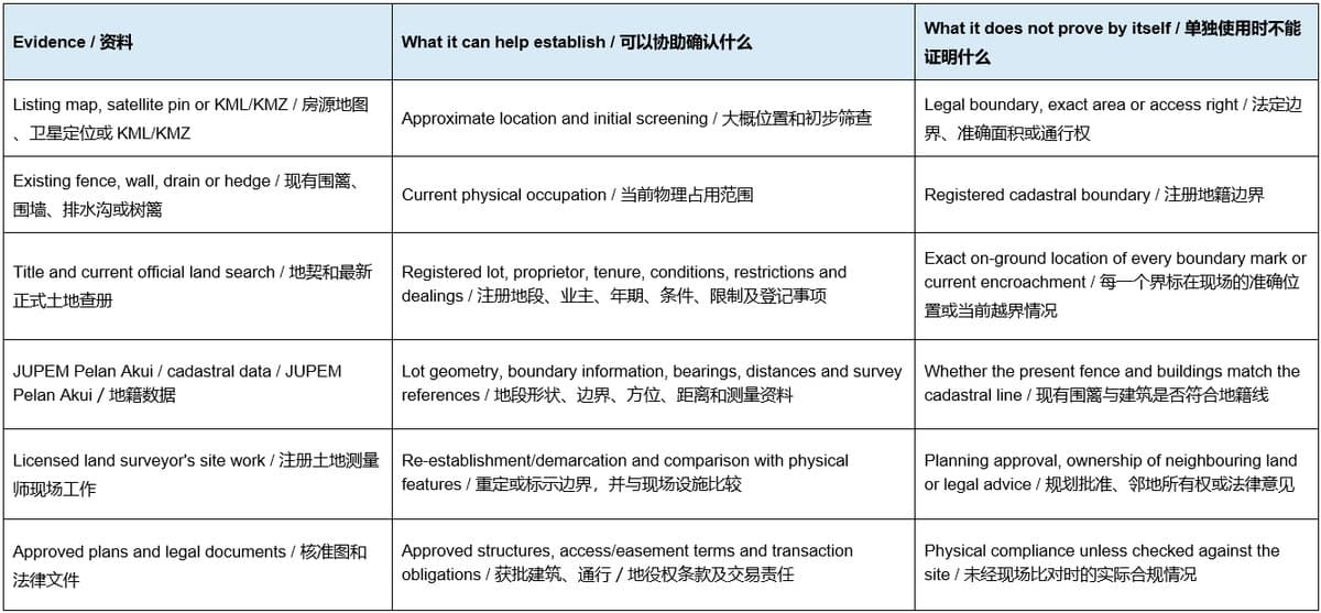
JUPEM's MyLot service can be useful for initial location screening, but its own notice states that the displayed information is for general information and should be independently verified.
JUPEM的MyLot适合做初步位置筛查,但其公告也说明,显示资料仅供一般参考,使用者应自行进一步核实。
The 11 boundary checks before committing
作出承诺前的11项边界检查
1. Confirm the exact title, lot and land system 核实准确地契、地段和适用土地制度
Obtain a current official title search and match the title number, lot number, mukim/section, district, state and registered area against the sale documents. Confirm whether the transaction involves one lot or several adjoining lots. Record tenure, express conditions, restrictions in interest, caveats, charges and any dealings that may affect the transaction.
取得最新正式土地查册,把地契号码、地段号码、mukim/section、县、州和注册面积与交易文件逐项核对。确认交易涉及一个地段还是多个相邻地段,并记录年期、明文条件、权益限制、私人禁令、抵押及其他登记事项。
This guide primarily discusses Peninsular Malaysia. Sabah and Sarawak have separate land and survey systems, while requirements can also differ by state and property type. Use professionals familiar with the relevant jurisdiction.
本文主要讨论马来西亚半岛。沙巴与砂拉越拥有不同土地及测量制度,各州和不同物业类型也可能有不同要求,应委任熟悉相关司法管辖区的专业人士。
2. Obtain the proper cadastral plan 取得正确的地籍图
Request the relevant JUPEM Certified Plan or other appropriate cadastral record. The eBiz description says a Pelan Akui displays lot information including location, lot number, area, bearings, boundary distances and corner coordinates.
索取相关JUPEM Pelan Akui或其他适用地籍记录。JUPEM eBiz说明,Pelan Akui会显示位置、地段号码、面积、边界方位、距离及角点坐标。
Confirm that the plan belongs to the same final lot—not an old parent lot, proposed subdivision or neighbouring parcel.
必须确认图纸属于交易中的最终地段,而不是旧母地、拟议分割图或邻近地段。
3. Appoint an appropriately licensed land surveyor 委任合适的注册土地测量师
If boundary position, area, access or encroachment is material, do not rely on a general site measurement.
如果边界位置、面积、出入口或越界问题会影响交易,不应只做一般尺寸测量。
Malaysia's Licensed Land Surveyors Act 1958 regulates licensed land surveyors and defines title-survey work to include delimiting land boundaries, dealing with boundary marks and recording the related measurements and plans.
《1958年注册土地测量师法令》监管注册土地测量师,并把权属测量工作定义为包括划定土地边界、处理界标,以及记录相关测量和图纸。
The scope should be clear: identify or re-establish boundary positions as appropriate, locate visible occupation features, compare relevant plans, and produce a drawing or report suitable for the transaction team.
委托范围应写清楚:按需要确认或重定边界位置、测量可见设施、比较相关图纸,并提供交易团队可使用的图纸或报告。
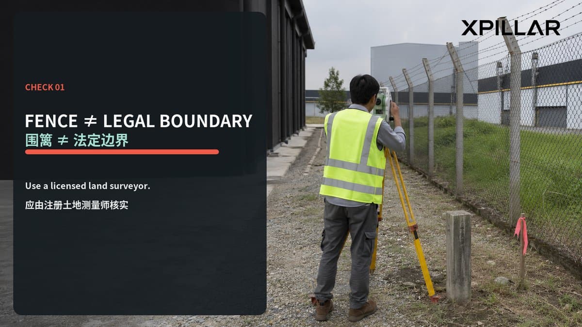
4. Compare the cadastral boundary with the fence 比较地籍边界与围篱
Walk every boundary where safe and accessible. Plot fences, walls, drains, retaining structures, gates, hedges and survey marks against the survey findings.
在安全和可进入的情况下走完整条边界,把围篱、围墙、沟渠、挡土结构、大门、树篱及界标与测量结果叠加比较。
A fence may have been placed for convenience, moved during earthworks, aligned around a drain, or built before a subdivision was finalised.
围篱可能为了施工方便而内移,也可能在土方工程时移动、为了避开排水沟而改变方向,或在分割地段完成前就已建成。
Classify each segment/ 可把每段边界分类为:
- fence substantially follows the verified boundary;
围篱大致符合已核实边界;
- fence is inside the lot, so part of the buyer's land is outside the enclosure;
围篱位于地段以内,买方部分土地被留在围篱之外;
- fence is outside the lot, so the property occupies neighbouring or reserved land; or
围篱位于地段以外,物业实际占用邻地或保留地;或
- position remains uncertain and requires further investigation.
位置仍不确定,需要进一步调查。
5. Locate every building and improvement 测量所有建筑和设施
Survey the factory, warehouse, office, guardhouse, pump room, canopy, external tank, loading dock, retaining wall and other permanent improvements.
测量厂房、仓库、办公室、保安亭、泵房、雨棚、外部储罐、装卸台、挡土墙及其他永久设施。
Check whether any structure crosses the boundary or sits too close to it for the approved setback and fire strategy.
检查是否有结构跨越边界,或因为过度靠近边界而影响批准退界及消防策略。
Then compare the surveyed position with approved building and planning plans. A structure physically inside the fence may still be outside the legal lot or inconsistent with the approved plan.
之后再把测量位置与核准建筑图和规划图比较。一个结构即使位于围篱以内,也可能已经超出法定地段或不符合核准图。
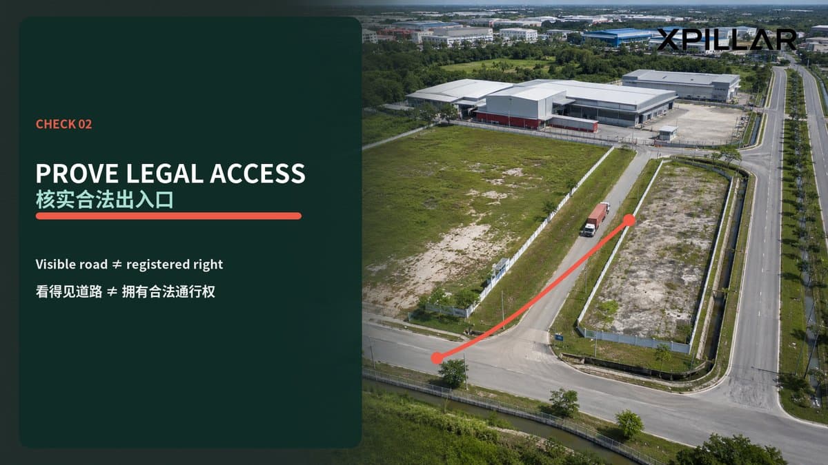
6. Prove the legal access—not just the visible road 证明合法出入口,不要只看得到道路
A formed road to the gate does not automatically prove that the property has a registered or secure right to use it.
有一条已经铺好的路通往大门,不代表该物业必然拥有登记或稳定的通行权。
Identify where the lot meets a public road or recognised road reserve. If access crosses another title, determine the legal basis, route, width, duration, maintenance responsibility, vehicle class and transferability.
要确认地段在哪里直接连接公共道路或已确认的道路保留地。如果通道穿过其他地契,应查清法律基础、路线、宽度、年期、维修责任、允许车辆类型及是否可随交易转移。
For an industrial operation, test the legal access against the actual design vehicle, abnormal loads, emergency access and shift hours.
工业用途还要按照真实设计车辆、超长或超重设备、紧急车辆及轮班时间测试通道。
A narrow informal route may be inadequate even if cars currently use it.
一条目前小汽车可以使用的非正式窄路,未必能支持工业运营。
7. Identify easements, wayleaves and utility corridors 核实地役权、通行权和公用设施走廊
Map registered and known rights affecting the site: access, drainage, sewerage, electricity, gas, water, telecommunications and shared industrial-estate infrastructure.
把影响土地的登记及已知权利全部绘制出来,包括道路、排水、污水、电力、燃气、供水、电讯及工业园共用设施。
Confirm who owns the infrastructure and who may enter for maintenance.
确认设施由谁拥有,以及谁有权进入土地维修。
Also check the reverse question: does the factory depend on pipes, cables, drains or roads located on neighbouring land without documented rights?
也要从相反方向检查:厂房是否依赖位于邻地的管道、电缆、沟渠或道路,却没有文件支持?
An operational utility is not automatically a permanent legal entitlement.
设施目前可以使用,不代表企业永久拥有合法权利。
8. Screen reserves, acquisitions and planning proposals 筛查保留地、征地和规划建议
Compare the lot with road widening, drainage or river reserves, rail or utility corridors and other public proposals.
把地段与道路拓宽、排水或河流保留地、铁路或公用设施走廊,以及其他公共规划比较。
Review the applicable local plan and planning information, then obtain authority confirmation where the proposal could affect area, access or development layout.
查阅适用地方规划和规划资料;如果建议项目可能影响面积、出入口或开发布局,应向相关部门进一步确认。
Do not deduct a proposed reservation twice, but do not ignore it simply because the current fence includes the land.
不要重复扣除同一项保留地,但也不能因为围篱把土地围在里面就完全忽略它。
9. Recalculate net usable and net developable area 重新计算净可用及净可开发面积
Registered area is not the same as operational area.
注册面积不等于运营面积。
Starting from the verified lot, deduct or allow for:
应从已核实地段范围出发,扣除或考虑:
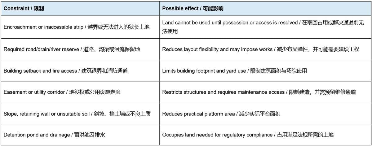
Reprice the property using the verified area and the cost of creating a workable layout, not the brochure acreage alone.
估值时应采用已核实面积及建立可行布局的成本,而不是只按宣传册英亩数计算。
10. Cost the rectification options 计算纠正方案的成本
For every discrepancy, define a realistic solution and owner:
针对每项偏差,列明现实解决方案和责任方:
- relocate the fence or gate;
移动围篱或大门;
- remove or regularise an encroaching structure;
拆除或合法化越界建筑;
- negotiate a formal access or utility right;
协商正式通行权或公用设施权;
- acquire or lease the affected strip, subject to approvals;
在取得批准的前提下购买或租用相关狭长土地;
- redesign the factory, yard, fire route or drainage;
重新设计厂房、场院、消防路线或排水;
- obtain amended approvals; or
取得修订批准;或
- accept a permanent loss of usable area and adjust the price.
接受永久损失的可用面积,并调整价格。
- Include survey, legal, authority, engineering, demolition, rebuilding, compensation and delay costs.
预算必须包括测量、法律、政府申请、工程、拆除、重建、补偿和时间延误。
“Can be solved later” is not a budget.
“以后可以解决”不是预算。
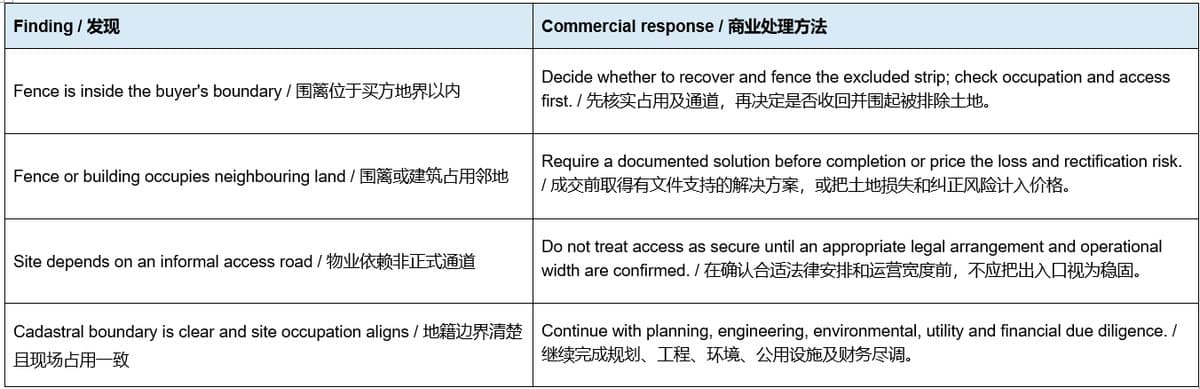
11. Put boundary outcomes into the transaction documents 把边界结果写进交易文件
The letter of offer, sale and purchase agreement or tenancy agreement should allocate the risk.
意向书、买卖协议或租赁协议应明确分配风险。
Depending on the property, consider:
视物业情况,可考虑:
- a due-diligence condition covering boundary and legal access;
以边界及合法出入口尽调满意为先决条件;
- permission for surveyors and consultants to enter the site;
允许测量师和顾问进入现场;
- delivery of titles, cadastral plans, approved plans and access documents;
交付地契、地籍图、核准图及通行文件;
- a defined survey or encroachment plan attached to the agreement;
把双方认可的测量图或越界图附在协议;
- seller responsibility and deadline for removal or regularisation;
规定卖方负责纠正的范围和期限;
- vacant possession of the whole agreed area;
交付双方约定的完整土地范围并确保空置占有;
- price adjustment if verified area falls below an agreed threshold;
已核实面积低于约定门槛时调整价格;
- retention, termination or deposit-refund rights if an essential issue cannot be resolved; and
关键问题无法解决时保留款项、终止交易或退还定金;以及
- representations drafted by Malaysian legal advisers for the specific facts.
由马来西亚律师根据实际情况起草陈述与保证。
Do not describe a property as “fully fenced,” “10 acres usable” or “direct public-road access” in the contract unless the evidence supports the statement.
除非已有证据支持,否则不应在合同中无条件写明“全地围篱”、“10英亩全部可用”或“直接连接公共道路”。
Documents to place in the data room 建议放入资料室的文件
- current official title search and title copy;
最新正式土地查册和地契副本;
- relevant JUPEM Pelan Akui/cadastral plan;
相关JUPEM Pelan Akui/地籍图;- surveyor's boundary, feature and encroachment drawing;
测量师边界、现场设施及越界图;
- approved layout, building and infrastructure plans;
核准总图、建筑图及基础设施图;
- subdivision, amalgamation or surrender-and-realienation records where relevant;
适用时的分割、合并或交回重批记录;
- access, easement, wayleave and shared-infrastructure documents;
出入口、地役权、通行权及共用基础设施文件;
- land-acquisition or authority correspondence;
征地或政府部门往来文件;
- neighbour agreements or dispute records;
邻居协议或争议记录;
- photographs of boundary marks, fences, gates and structures; and
界标、围篱、大门及建筑照片;以及
- rectification scope, budget, responsibility and programme.
纠正工作范围、预算、责任方和时间表。
Red flags during a viewing 看地时的危险信号
The agent can point to the fence but cannot identify the title lot.
中介只能指出围篱,却无法确认地契地段。
The acreage in the brochure differs from the current title or approved subdivision.
宣传面积与当前地契或获批分割面积不同。
A Google pin or owner-drawn KML is treated as a legal survey.
把Google定位或业主自制KML当作法定测量。
Boundary marks cannot be found and no survey has been commissioned.
找不到界标,同时没有委任测量师。
A warehouse wall, canopy, drain or guardhouse appears to follow a different line from the fence.
厂房墙体、雨棚、排水沟或保安亭的方向明显与围篱不同。
The only access crosses another occupied lot.
唯一通道穿过其他正在使用的地段。
Utility pipes or cables enter through neighbouring land with no documented rights.
公用设施经过邻地,但没有书面权利。
The seller refuses a boundary survey or access-document review.
卖方拒绝进行边界测量或审查通行文件。
The price assumes every square metre inside the fence is usable.
售价假设围篱内每一平方米都可以使用。
Rectification is promised verbally after completion.
只口头承诺成交后再纠正。
Conclusion 结语
The most important boundary question is not “How many acres are written in the brochure?” It is: What land is legally in the title, where is it on the ground, how is it accessed, what currently occupies it, and how much remains usable for the intended industrial operation?
最重要的边界问题不是“宣传册写了多少英亩”,而是:法律上哪些土地属于这张地契、它在现场位于哪里、怎样合法进入、目前有哪些设施占用,以及扣除限制后还有多少面积适合拟进行的工业用途?
A defensible transaction connects title records, JUPEM cadastral information, licensed survey work, approved plans, legal rights and physical inspection.
一宗可靠交易必须把地契记录、JUPEM地籍资料、注册测量工作、核准图、法律权利和现场检查连在一起。
When the evidence aligns, the buyer can value the land and design the operation with greater confidence. When it does not, resolve the discrepancy or price it before the deal becomes unconditional.
当证据一致,买方才能更有把握地估值和设计运营;如果不一致,就应在交易成为无条件之前解决偏差或把风险计入价格。
Frequently Asked Questions
常见问题
1. Is an existing fence proof of the legal land boundary?
现有围篱是否可以证明法定地界?
No. A fence shows physical occupation, not necessarily the registered cadastral boundary. Compare cadastral records with an appropriate on-site survey.
不可以。围篱只显示目前物理占用范围,不一定等同注册地籍边界,应把地籍资料与适当现场测量结果比较。
2. Can Google Maps, satellite images or a KML prove the boundary?
Google地图、卫星图或KML能否证明边界?
They are useful for screening and communication but should not be treated as a legal title survey. JUPEM's MyLot notice also advises users to verify displayed information.
这些资料适合初步筛查和沟通,但不应当作法定权属测量。JUPEM的MyLot公告也要求使用者自行核实显示资料.
3. What is a JUPEM Pelan Akui?
什么是JUPEM Pelan Akui?
It is a Certified Plan that displays cadastral lot information such as lot number, area, boundary lines, bearings, distances and corner coordinates. The correct plan must still be matched to the current title and site.
Pelan Akui是显示地段号码、面积、边界线、方位、距离和角点坐标等地籍资料的认证图。仍需确认图纸对应当前地契和现场地段。
4. Does a visible road guarantee legal industrial access?
看得到道路是否代表工业地拥有合法出入口?
No. Confirm where the lot connects to a public road or road reserve and document any right crossing third-party land, including width, vehicle use and maintenance.
不代表。应确认地段在哪里连接公共道路或道路保留地,并记录任何跨越第三方土地的通行权、宽度、车辆用途和维修责任。
5. What should happen if a building crosses the boundary?
如果建筑跨越边界,应怎样处理?
Obtain survey, legal, planning and engineering advice. Possible solutions include removal, redesign, documented rights, acquisition or lease of the strip where legally possible, amended approvals or a price adjustment. Do not rely on a verbal promise.